ECan recently released their draft long-term public transport plan for Christchurch and Timaru. On the other side of the globe, Jarrett Walker and co are proposing a new bus network for Dublin. The proposed Dublin network centres around the concept of a ‘spine‘ – a collection of frequent bus routes that use the same corridor in the central city, turning that corridor into a very frequent transit line.
The proposed Christchurch network consists of frequent ‘core’ routes and less frequent ‘connector’ and ‘cross-city’ routes. ECan’s definition of frequent is a bus every 10-15 minutes, with the idea being that you can just turn up to one of these bus stops without needing to consult timetabling material, knowing that you won’t have to wait long.
Here’s a sketch of what they’re roughly proposing, in schematic form:

Their network has a radial topology, with 9 lines radiating out from the central city and one orbital line. New lines (with my own unofficial labelling) are Magenta, Brown, Green and Red. Under this network, a lot of Christchurch gets better service (see Chris Morahan’s model). However, could we combine some of these frequent routes into common rapid transit corridors? Below is an attempt:

Under this altered network, we have two main lines — A (North/South) and B (East/West) – that branch into individual lines after travelling along common corridors. This would mean the Papanui to Moorhouse and Riccarton to CBD lines would be incredibly frequent, with a bus every 4 minute-ish. I’ve also shown heavy rail for a potential connection point at Moorhouse. Now, the spines aren’t just collections of bus routes travelling along the same road — they are intelligently timetabled frequent routes, so that there’s a bus every 3ish minutes, 7am-7pm every day.
I don’t think this is better, though. The extra frequent coverage under ECan’s plan is hard to argue with, and I doubt the benefits of a couple of very rapid corridors outweigh that.

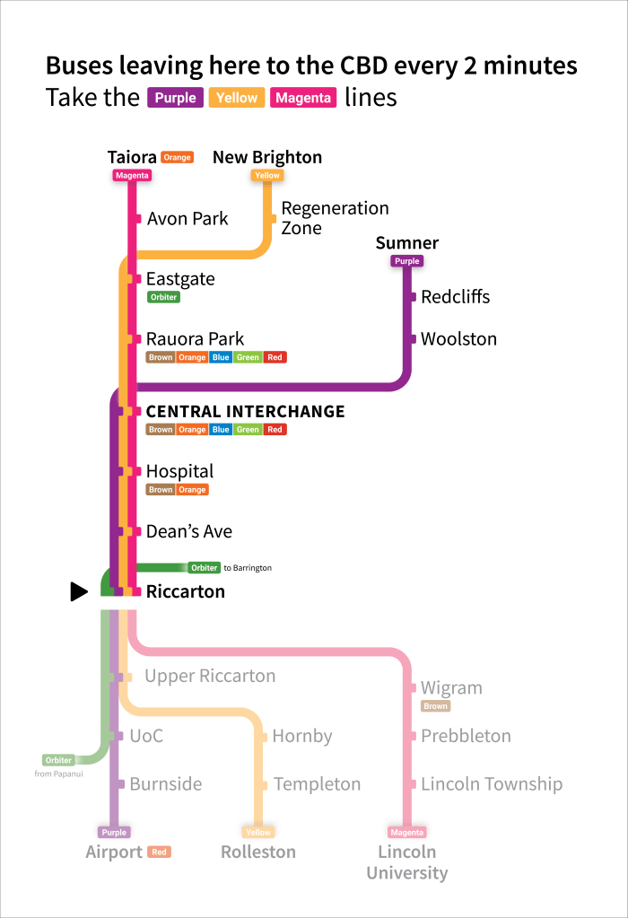
Wayfinding can help promote rapid corridors without needed to re-label and re-route routes to form spines. For example, plinths like these two above would be well suited outside Westfield Riccarton and at a Moorhouse Ave stop, where buses will likely be every ~2-4 minutes at peak times under their network. This sort of signage would ensure people view the core network as a cohesive whole and help cement main corridors such as Riccarton – CDB and south Colombo St as rapid transit routes that can be travelled on without pre-planning.
