
Last year, the esteemed Wellington Sea Shanty Society (WSSS) released their EP, Sea Shanties of the 70s, 80s and Today!
They reached out to pitch a neat idea to accompany their EP launch: a riddle and treasure map that combine to guide you to a secret cache of bounty. They had an amazing riddle all prepped — they just needed a treasure map to go with it.
The Punters’ Challenge
Hark!
Where the beach is black
& there is fierce and foul weather
When the bowline is slack
The southerly speaks…
Is this the treasure you seek?
Then scramble you must from shore to peak
Escarpment or beaten track will lead you there
To the site from which threats of the sea become clear
Is this the stronghold of a white faced sheep?
Nā Rangitane tēnei pā i whakatū?
Bring no spade, for no treasure is buried
Merely three figures in the shadows, waiting to be ferried
But what, pray tell to do next?
A smooth sea never made a skilled sailor.
Nā reira, kia tūpoto e hika!
For all of your work no dinner allowed
Just a pint of ale with a good shanty crowd

The above riddle and map give all the information you’ll need to locate the site of the treasure!
Designing the Map
There were a few steps to this treasure hunt:
- The riddle points to the general vicinity of a code number.
- The map guides to the exact location of the code.
- The riddle also points to where to use that code.
So WSSS needed a map that:
- Wouldn’t give away the general location it’s depicting (that’s what the riddle’s for!), but
- Once you know the location it should make sense at a very detailed level.
The general location was Breaker Bay on Wellington’s south coast, and one of the old WW2 bunkers on the ridge was the specific point we needed to direct to.

Breaker Bay is pretty well known in Wellington — it’s a nudist beach, it has a number of disused WW2-era gun emplacements, it’s the site of a former Pā (which can be seen in the lower right of this 1907 map), and it’s a popular place for strolls, saunters, and dawdles.

All-in-all, the shape of the coastline would be pretty recognisable. I needed to do something different that just showing a bird’s eye view of the geography. I started trying 3D drawings — but for whatever reason I just wasn’t vibing the concept.

But what if! Land is now sea and sea is now land.
Using QGIS, I imported some coastline data into Illustrator and messed around roughening and softening the lines; adding and removing detail; inventing new landforms and removing others. I’m not from Wellington — so I was unsure of liberty I ought to take with making up and moving coastlines in order to keep people needing to use the riddle, but also to not be put off the correct location by thinking the map is showing some place wildly different.
I think that what I ended up with worked well.
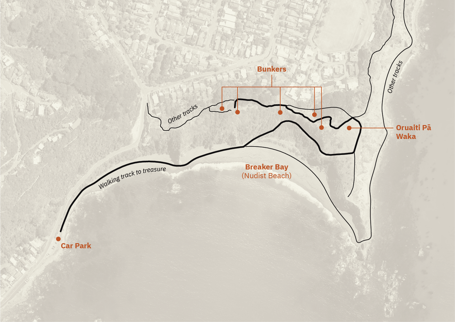

I included a few hints that would hopefully cement suspicions of Breaker Bay being the secret location, and help with locating the right bunker when there:
- The WW2 bunkers are shown as islands
- Three distinctive rock outcrops in the lower left remain
- All walking tracks are shown, with the suggested route highlighted
- An anchor signifies the car park
- A shipwreck denotes a waka sculpture
- Shirtless Poseidon beckons to the nudist beach
Finally, all lines were roughened up through layered Illustrator effects, and other bits and bobs were added to make the whole thing feel more treasure-map-y.
The Result
Someone worked it out! A success! WSSS posted it around on their socials and inspired some hearty discussion in the comments.
And Maya got it! (And I was stoked to see that some of the references were understood!) From her comment on the Facebook post:
Ok. So.
Where the beach is black and there’s fierce and foul weather: Breaker Bay has black sand but there’s foul weather everywhere. it’s Wellington. The anchor on the map looks like it could be a community hall the WSSS plays at. I never quite got the Poseidon reference- maaaaaybe it’s about the nudist beach there? 😬 “the stronghold of a white faced sheep” – Dorset is a kind of sheep and there are old gun emplacements at Fort Dorset above Breaker Bay, up the escarpment. You can also access it via “beaten track” as per the riddle. And it’s the site of Oruaiti Pā, which was possibly originally occupied by Rāngitane.The topography lined up, so I spent many more hours than I’d like to admit up there, over two weekends, but couldn’t find the “three figures,” although I knew they were “in the shadows” in one of the bunkers.
“No dinner allowed” was a reference to Tinakori Hill: there’s a folk etymology that it comes from “Tina kore”, for “no dinner.” So I went to the Fork & Brewer (where WSSS has played, thus the “good shanty crowd”) for a “pint of ale,” and after an hilarious conversation with the very lovely bartender I was asked for three numbers. I’d never found the “three figures” but it clicked that I’d been looking for the combination code to a padlock. Luckily I’d spent so long examining every inch of the graffiti in that bunker that I knew the numbers that were written on the walls.
Thank you very much for this fun (and at times, infuriating) treasure hunt. Su Keates’ jewellery is beautiful, the rum is great, and I appreciate the tickets to your show, where I promise to only sing a normal amount of loud.
All my friends (who’ve listened to me obsess about this for days) are asking when the next one is happening 😂
