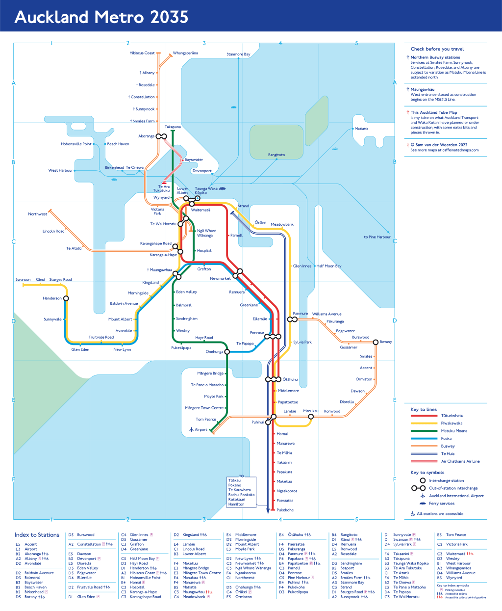
I posted about this map in July 2021, saying I’d never finish it. I also chucked it up on Twitter and few people urged me to not trash it. So after a year and a half, I finally did! (Click for full size)

Assumptions
This map features a hypothetical Tāmaki Makaurau metro network in the 2030s. I’ve made a bunch of assumptions for this map, including lines, service patterns, stations, names, facilities, and future projects. Some assumptions I’m confident in; others may be a tad optimistic or fanciful. So this map could represent the future network, but in my mind it’s really about getting excited for future possibilities.
My assumptions:
Railways
- The extent of the existing heavy rail network will remain (with the additions of City Rail Link tunnel and stations in the City Centre, and new Drury stations). A new service pattern will run on it.
- A new light rail line will run between the airport and Takapuna. It will be extended northwards along the busway alignment and beyond.
- A new light rail line will be under construction between the Northwest and the City via Maungawhau.
- A new station at Strand will link the metro network to Te Huia.
Busways
- A new Airport to Botany busway will be in place.
- The Eastern Busway will run all the way to Botany.
- The Northern Busway’s extent will include the Penlink bridge into Whangaparāoa.
- The interim northwest bus improvements will be in place. (I know many argue this isn’t a busway, and I agree. However, a map like this doesn’t just communicate the infrastructure and services on the ground, but also the intention for how people get around the city. In this case, the intention is for people to use this service as their primary travel option to the northwest, so I think it deserves inclusion.)
Ferries
- No change to existing network, except removal of Birkenhead service. This is due to…
Cable Car!
- A new cable car service runs between Wynyard Quarter (specifically Te Ara Tukutuku, a new public space being planned), Birkenhead, and Akoranga busway station. This service has been pitched by the ropeway company Doppelmayr. (And I genuinely reckon we should do it!)
Design
Three years ago I tried my hand at the Tube Map design system for the first time, with an early version of this Auckland Tube. While I don’t think the Tube Map system is the best possible transit mapping system out there, I think it has potential to produce some really lovely maps with gorgeous, crisp details. Its simplicity allows designers to tweak, remove, and add elements while keeping the distinctive Tube feel. Examples of such maps are Jug Cerovic’s London Underground Map and Cameron Booth’s New York Tube Map. My map has been inspired a lot by Cameron’s design.
Line Names
I chose to name the rail and light rail lines after native birds relevant to their geographies. I don’t think this sort of line naming system would be particularly good in practice, but it ties in with the interregional Te Huia line and it adds a distinctive flavour to each line, like the Tube network does in London.
- Tūturiwhatu / New Zealand Dotterel: a shorebird found in the Manukau Harbour, which this line brushes around.
- Pīwakawaka / Fantail: a small common bird found throughout backyards and the suburbs. Its flight is very zippy and flitty, which I think nicely matches how this line looks on the map.
- Matuku Moana / White-faced Heron: a bird of rocky shores and estuary mudflats found around the Manukau and Waitematā Harbours. This line crosses both these harbours.
- Poaka / Pied Stilt: a shorebird found in the Manukau Harbour, which this line meanders towards.
- Mātātā / Fernbird: a wee bird who hangs out around the Whau River, which this line would eventually cross as it heads out west.
This project ticks off number 1 in my longlist. Up next: probably an InterCity coach network map. Or nothing for a while.
